Picto Diary - 07 June 2017 - Miles Canyon, YT
Today's ride (07 June 2017) is from Watson Lake, YT to Whitehorse, YT. Along the Alaska Highway. 275 miles. Short ride. Time to contemplate sites along the way and to spend some time exploring Whitehorse and environs.
Last year, plying this route, we rode from Liard Hot Springs, BC, on the Alaska Highway, to Whitehorse, 404 miles.
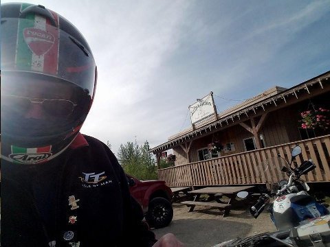
Above: Kathy's Restaurant. Watson Lake, YT. 07 June 2017.
My typical breakfast is two scrambled eggs and a bowl of oatmeal.
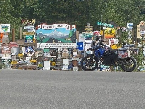
Above: Signpost Forest. Watson Lake, YT. 07 June 2017.
Probably the largest public display of stolen property in the world. There are 80 K location signs here. The practice was started during WWII by the construction workers building the Alaska Highway.
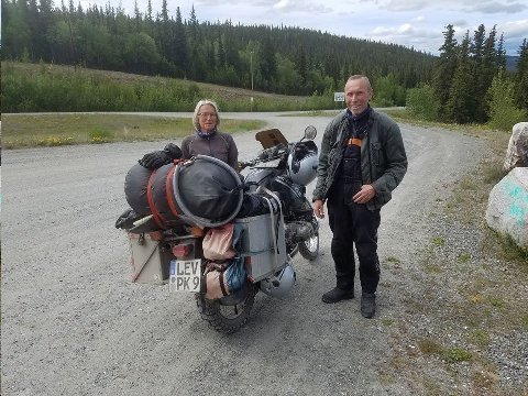
Above: Herbert and Gelsa, Cologne, Germany. Teslin, YT. 07 June 2017.
These true motorcycle adventurers are riding a '95 BMW Paris Dakar (PD) motorcycle. Among motorcycle aficionados, the PD has iconic status.
Herbert and Gelsa started their trip in Nova Scotia. They are headed to Dawson to attend the "Dust to Dawson Motorcycle Rally," on 15/16 June 2017. They plan on ending this phase of their trip in Seattle, three weeks from now.
The starter broke on their PD. They have to roll the bike to get it going. The image shows them parked on a hill above Teslin, YT so as to use gravity to get the bike moving to pop the clutch for an engine start. They have ordered a replacement starter to be shipped from Denver to Dawson.
Germans are, hands down, the world's uber adventure travelers.
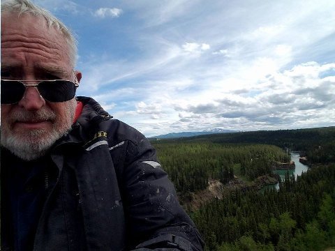
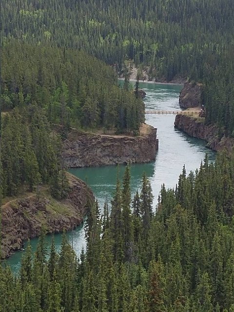
Above: Two images of Miles Canyon and Yukon River. Whitehorse, YT. 07 June 2017.
The bridge (walking only) is only one of a half dozen bridges or so that span the 2000 mile length of the Yukon River.
A few years ago, while riding a Kawasaki KLR motorcycle up to Prudhoe Bay, I crossed the Yukon two hundred miles north of Fairbanks, on a large span which accommodated the big "ice road" trucks plying the Dalton Highway to Dead Horse (Prudhoe Bay).
I walked across the Miles Canyon bridge, seen in the image, while visiting Whitehorse last year at about this time.
The river seen here is backed up by a dam, constructed in 1959, two miles down stream. So the flow here is placid and easy flowing. The reservoir just above the dam is called Schwatka Lake.
Before construction of the dam, Miles Canyon had class five rapids.
In Klondike gold rush days, 1898, many miners died trying to navigate down the White Horse rapids on their way to Dawson City and the Klondike River gold. After too many casualties in the rapids, a portage service was set up on each side of the river.
So much water up here! Nobody uses it. Pipeline to San Diego?
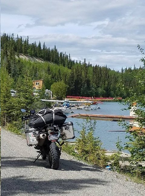
Above: F800GS motorcycle and float planes in Schwatka Lake. Whitehorse, YT. 07 June 2017.
John Galt's dream. Whitehorse would seem to be a good place for Galt's Gulch in any case.
Post visiting Miles Canyon and Schwatka Lake, I checked into a Best Western Motel, walked around Whitehorse, and dined at G and P Grill (good place).
Addendum:
Steve,
The most famous event that happens in Omak, is the suicide race. This happens annually in conjunction with the Omak Stampede. They have tried to stop the event on numerous occasions because of the danger to the horses. However, because the race is on a reservation and most of the riders are native Americans the event continues. About eight riders, starting on foot run to their horses race for about one hundred yards, then go down a very steep cliff, where often the horses will stumble along with riders. At the bottom of the cliff they enter a river, ford it for about fifty yards, race up the other side Nd race into the show grounds. Very exciting and winner has serious bragging rights for the year. The stampede , run by the native Americans is a spectacular event that goes on for several days. Worth the effort.
Bill,
Tacoma, WA
I'd love to see this sometime. I've been motorcycling in and around Omak for years, but, have missed this.
Devil's island is actually very pretty, you could walk the whole island in about two hours. The day we were thee it was misty so the steps up to the museum and various buildings were slippery, also muddy paths. We saw monkeys and agoutis (small brown furry creatures, rat like but without a tail.), macaws and of course it suppose to be surround by sharks (but I did not see any). There are drop offs to the sea with rocks. We saw people staying there and fishing. There are three islands in all. We went to the main one where the prison was.
Bridge,
Palm Beach FL
We're doing a Panama Canal cruise later in the year... but, we'll miss Devil's Island. Bummer.
Steve,
If you haven’t seen it, try to get your hands on today's Sunday NYT on your journey. Sports section has a great, long piece on the Isle of Man TT race.
Incredible course, incredible riders.
Tom,
Aspen, CO
Thanks Tom. I was a spectator at the TT in 2015. I rode a rented motorcycle from Bornmouth, UK to Liverpool and took a ferry over to the Isle of Man. I was able to ride the Mountain Course when it was opened to amateur riders. I'm guessing I rod at 1/3 the speed of the winning racers. However you feel about the gladiator-like aspect of the TT, it is thrilling to watch. A truly iconic sporting event.
Last thing at night is to catch up on your vision quest and drift off to my Walter Mitty world.
Peterbilt,
Salt Lake City, UT
The lack of roads north to Canada reminds me of the great difficulty traveling from Moscow east to Vladivostok. Maybe that is a ride you should try if you have not already done it.
Looks like you are having a great trip. Be safe. Look forward to seeing you when you get back.
The Monk,
Salina, UT
I've ridden through Dagestan, Chechnya, Ingushetia, and North Ossetia. Riding in Russia is very challenging. One of the only places I have ridden where there is nothing... nothing... road signs or whatever in the English language. A friend of mine attempted the Vladivostok ride, but, gave up somewhere along the route.
Dear Steve,
Does the couple that run the Air force Lodge in Watson Lake. YT, require you to remove your boots and leave them near the entry door?
The Cassiar Highway was created as a logging road (dirt) and was still mostly so when Anni and I first traveled on it in 1996 in an SUV. The province of British Columbia had decided to encourage development of that area by paving the road. During subsequent years and on various different motorcycles, the paving became more complete so it is now done. The development? … “we’ll see”; BUT as you no doubt noticed, there is now a high capacity electric transmission line strung along the road which was still under construction last year. I asked a construction flag woman which way the electricity was going to flow and her answer: south to north to service a mining facility located around the northern sector of the “Cassiar”. Maybe this is the “planned-for” development. The helicopters I saw last year were rather like a swarm of bees around the actual construction activity- installing the towers, stringing the electric cable, etc.
Anyway, thanks for re-kindling fond memories of a pretty part of the world.
Please enjoy the “Top of the World” “highway” (a dirt road) a you ride along the ridge, approximately 40 KM, where mountain peaks are receding from you in 360 degrees for the entire time- not necessarily spectacular at any one point; bit the continuation is striking- well, I think so.
A t-shirt from Chicken, AK?
Thanks for your travelogue and enjoy the ride.
Ahn Rhee, Larkspur, CA
Yep. The Same. No shoes. The place was very clean... that was the major plus. Great supplement on the Cassiar! Thanks! Looking forward to "Top of the World, (which I actually rode yesterday... but, I can't get ahead of myself... check my Facebook posts which are more current)! OK... I bot a cap not a shirt!