Picto Diary - 15 June 2016 - Haines Highway
Day 8. 15 June 2016. Tok, AK to Haines, AK. 460 miles. 2012 BMW F800 GS motorcycle. Return to join my mates in Haines, AK after having completed gap closing segment to claim a continuous motorcycle ride from Park City, UT to Prudhoe Bay, AK.
Today's ride was a "top ten" ride in my motorcycling experience... for reasons both good... and less good.
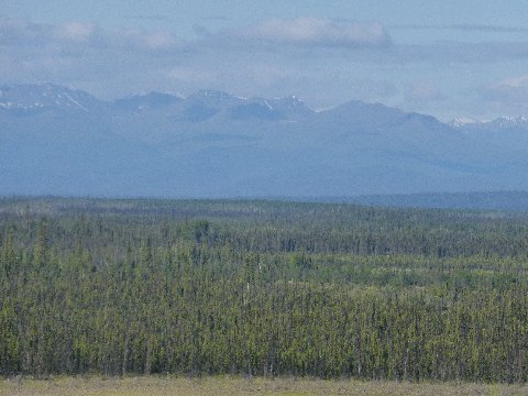
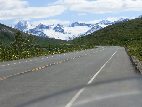
Above: Terrain south of Alaska Highway 50 miles south of Tok. 15 June 2016. Image looks southwest.
The Wrangell Mountains, seen here, are part of the Pacific coastal ranges of North America. Further on (southwest) these mountains are eclipsed by a larger coastal range, the St. Elias Mountains.
These ranges will always be to my right as I ride south, across the US border back into The Yukon (Canada) and then back into the United States one hundred miles down the Haines Highway from Haines Junction, Yukon.
Further on, the massive coastal ranges include several 16 to 18 thousand foot peaks in the United States (Alaska) and Mt. Logan, Canada's highest mountain, at more than 17 thousand feet.
The ranges form part of one of America's largest national park. Wrangell-St. Elias National Park. Canada has created Kluane National Park adjacent, and together the two National Heritage Site parks form the largest protected area in the world.
I will just skirt by Wrangell-St. Elias, Kluane as I ride towards Haines. I won't likely have the opportunity to go deep into the parks during my life's remaining years. Only when you think that you are a real traveler do you come to realize how much more out there there is to see that you will never see. Most of Kluane and Wrangell-St. Elias will only ever bee seen by bears in any case.
Geographical specifics only dimly understood come to life when you are "really there." My mind's map takes shape quickly riding in this area.
Heretofore I had thought of the main part of Alaska and the inside passage (panhandle, marine highway) part of Alaska as being more or less two separate geographies, connected by land, yes, but really only reachable, one to the other, by water. But, today I find myself riding the road link between the two Alaska segments: Tok, AK to Haines, AK. From Haines I'll rejoin my mates and we will, on 16 June 2016, take an Alaskan Maritime Highway ferry, Matanuska, down the inside passage to Prince Rupert, BC... back, again, into Canada.
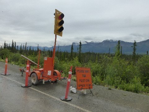
Above: Construction notice. Alaska Highway. Forty seven miles of dirt between Beaver Creek, Yukon and Destruction Bay, Yukon. 15 June 2016.
There were two one way segments, each one four or five miles long, with a pilot car guiding the caravan of one way vehicles.
No other motorcycles were in my piloted chain of about 15 vehicles. I didn't see any oncoming motorcycles for the entire forty seven segment. Maybe riders had heard about the horrendous condition of this road due to recent rains and decided to postpone their ride through.
I rode up through this segment of the Alaska Highway day before yesterday. My 2012 BMW F800 GS dual sport motorcycle is a pretty good bike for riding this type of terrain. Washboard. some ruts... stages of hard pan morphing to deep gravel, and back. The bike sits high of the road surface and has a wide band suspension rebound.
The ride up, two days ago, was not too bad. It had just started to rain when I reached the construction section... but, the underlying road was dry and pretty stable. In fact, the new rain contributed to minimizing the dust while not having been present long enough to muddy up the road.
Not so today.
Throughout the long construction section, the road surface was saturated.
I was wearing rain gear. The woman clerk at the convenience/gas station at Beaver Creek, in response to my query about the weather further on, said, "rain, rain, rain... for the last three days." It was not raining as I rode through the construction zone, but, it was clear that the road had been saturated by a huge amount rain before I arrived.
All the wet dirt riding hazards were there. Slick as snot, grease surfaces and freshly graded soft, wet... trending to mud... dirt. When I hit these hazardous conditions, I'd do the best I could to minimize the torque of the bike. A slipping wheel could easily spin the bike to the ground. A piece of dry dirt which I might ride in third gear at 5000 rpm, I would ride wet in fourth gear at 2000 rpm... almost to the point of lugging.
Not all of the wet, dirt road was super bad. Where there was gravel... or where the dirt was less clay like, the riding was more sure.
I was glad when I arrived at pavement.
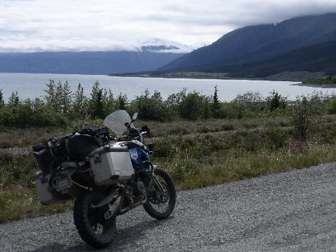
Above: Mud coated 2012 BMW F800 GS motorcycle. Kluane Lake. South of Destruction Bay, Alaska Highway, Yukon. 15 June 2016.
Is this Patagonia or the Yukon? I'm confused.
Patagonia and Yukon/Alaska are at similar latitudes on opposite ends of the globe. It is not surprising that the terrain is similar.
Now, on to Haines Junction, and the Haines Highway... 50 miles distant where I will be Alaska Highway for the first time since Dawson Creek, Alberta, five days ago.
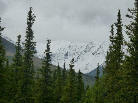
Above: Kluane Range mountains, opposite Kluane Lake. South of Destruction Bay, Alaska Highway, Yukon. 15 June 2016.
This is new snow and testament to the fact that there was a lot of moisture in this area over the last three days.
Note: As I edit this piece on 20 June 2016, I learned from another rider met en route that the road from Whitehorse, Yukon to Dawson, Yukon, was washed out in over 20 places rendering it impassible. I wonder how many of the "Dust to Dawson" motorcycle rally riders were stranded in Dawson? These Dawson rains are the same rains that muddied up the construction route along the Alaska Highway I took on 15 June 2016.
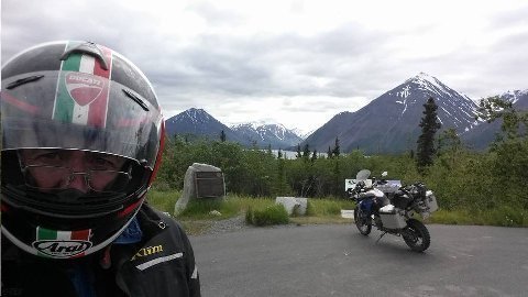
Above: Bishop and bike, 2012 BMW R800 GS, at overlook, Kluane National Park, Yukon Canada. Haines Highway. Yukon. 15 June 2016.
Stunning.
I've ridden 50 or so miles of the 160 mile long Haines Highway, from a pit stop at Haines Junction, to get to this point. In 20 or so miles, I'll re-enter British Columbia, and then, 70 miles before Haines, cross the US border back into Alaska.
There have been less than a dozen oncoming vehicles since I left Haines Junction, Yukon. I haven't come up on any vehicle moving my direction, nor has any vehicle come to overtake me.
The feeling is one of stark, isolated, beauty. How can such a beautiful spot not have more visitors?
Then, I realize how far this place is away from every place else. Forget Salt Lake City... this spot is over 1600 miles from "nearby" Edmonton, BC.
Still, I wonder how may Alaska Highway diehards know about the spectacular beauty of this Haines deviation. How many of them take it?
Yogi Berra: When you come to the fork in the road, take it.
Above: Tatshenshinni area of Kluane National Park. 2012 BMW F800 GS motorcycle. Haines Highway. 15 June 2016.
According to nearby story boards, this area was home to the Tatshenshinni Indians. It is also home to the highest concentration of brown bear (grizzlies) in the Yukon.
Words don't do justice as I look out over this expanse. Breathtaking.
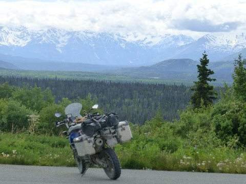
Above: Mountains. Haines Highway. Ninety miles north of Haines, AK. 15 June 2016.
One of hundreds of pictures I could have taken. Every turn of the road over 160 miles offered a vista as spectacular as this one.
Nobody on the road. High speed, well engineered, sweeping curves.
Of course, "nobody" on the road also means, nobody will find you if you run off the road... except perhaps a brown bear.
I kept speed below 75 MPH, but, the sweeping curved road lent itself to faster speeds should a rider want to push the envelope.
I think back. When have I ridden such a spectacular mountain motorcycle road... one which combined vistas and road conditions at exceptional levels?
Military Highway over the Caucusus from North Ossetia to Georgia? Admittedly great views... but road surface irregular and quite a bit of traffic.
Million Dollar Highway between Silverton, CO and Euray, CO? Vistas a nine compared to Haines Highway 10. Also, more traffic, and lower quality highway surface.
Tail of the Dragon between North Carolina and Tennessee? Iconic. But, not even close.
Altiplano highway from Ayacucho to Abancay (Peru)? Nuh Uh.
The Atlas range road from Ouarzozale to Marakkesh (Morocco)? Beautiful, but not like this. Also, the road surface was irregular.
Ride this road to motorcycle riding Nirvana. Trust me.
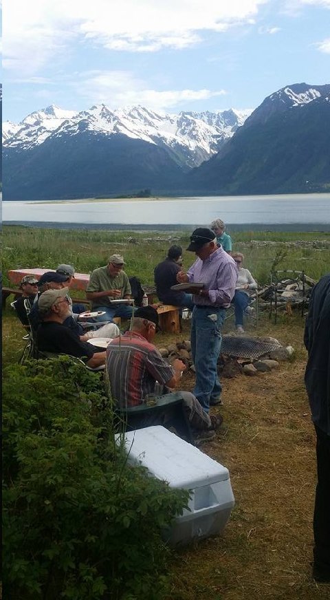
Above: Moose barbeque at home of Fran and Roger. Haines, AK. 15 June 2016.
Moose, taken by Roger up the river, was terrific. A meal like this has more meaning when you know your host had to put in some work... shooting... hauling... dressing... storing... to render the meal.
The moose was excellent. Moist. Tasty. Ambiance including meeting Galt's old friends was fun.
The scenery (as can be seen in the above image), however, left something to be desired.
Addendum:
Try our back yard! (bear)
Teeth and Energizer Bunny,
Basalt, CO
The hotel looks particularly inviting.
TIMDT,
Park City, UT