Picto Diary - 24, 25 September 2017 - TIMDT's 39th
10:30 AM EST. SUNDAY -
Seven Seas Mariner, northbound at 21 knots (full speed) in Florida Straits 85 miles east of Jupiter, Martin County.
Await Cap'n report, but we have to squeeze through the gap between Hatteras and Maria to get to NYC by 27th AM.
Interesting conundrum: how much risk to take in order to stay on schedule? Breaking schedule means disrupting the next cruise where NYC passengers will be unable to leave as expected.
Stay tuned.
PS. Norcross talked US through Andrew 25 years ago. Never expected to depend on his reports a second time.
Bryan Norcross added 2 new photos.
23 hrs ·
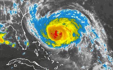
Sunday update: HURRICANE MARIA is on track for a close brush with eastern North Carolina and the southern part of the Mid-Atlantic coast midweek. Winds will increase in North Carolina on Tuesday and spread north to eastern Virginia and the Delmarva Tuesday night into Wednesday. Odds slightly favor the worst of Maria’s winds staying offshore, but damaging winds are increasingly likely.
Maria is forecast to continue weakening, but is still expected to be a hurricane when it arrives in the coastal waters of North Carolina. The storm has grown larger – the eye is now about 35 miles across and the winds over 40 mph extend out nearly 200 miles on the west side of the storm, increasing the likelihood of the strong winds extending inland.
A notable aspect to this storm is going to be its slow motion – meaning the winds will seem to relentlessly blow off the ocean – when it tracks near North Carolina. Strong east to northeast winds are going to persist for two days or more on the Outer Banks and a good part of that time in the Tidewater of Virginia and the Delmarva. Persistent strong winds loosen trees and power poles and are more likely to cause outages, as we saw in Irma in South Florida.
The steering continues to be subtle and complex. Currently Maria is being steered north around the west end of the Atlantic high-pressure system into a gap cause by former-hurricane Jose. Jose is gone, but a slight weakness in the high persists. By Tuesday, however, the gap will fill and a Canadian high, which trapped Jose off the north coast last week, will briefly control the steering, pushing Maria toward the coast and slowing it down – much like Jose was affected off New England. The high keeps Maria near or over eastern North Carolina through much of Thursday when a dip in the jet stream comes along to scoop up Maria and fling it out into the Atlantic.
The precise strength and, therefore, influence of these weather systems is impossible to know, which adds uncertainty to the forecast. In addition, because the strongest winds will still be concentrated near the center of Maria, a slight jog one way or other will make a big difference in the strength of the winds at the coast.
Hurricane or Tropical Storm Watches are likely along the coast. Be ready for a long-duration wind event on the Outer Banks, the Sounds, and nearby areas.
Here are the KEY MESSAGES from the National Hurricane Center at 5:00 am ET:
1. Maria's forecast track continues to be northward, paralleling the U.S. east coast, and it is likely that some direct impacts will occur along portions of the coast next week. Interests along the coast of the Carolinas and the Mid-Atlantic should monitor the progress of Maria, as tropical storm or hurricane watches may be needed for part of this area later today.
2. Swells from Maria are increasing along the coast of the southeastern United States and are expected to reach the Mid-Atlantic coast today. These swells will likely cause dangerous surf and rip currents at the beach through much of next week. For more information, please monitor information from your local National Weather Service office at www.weather.gov.
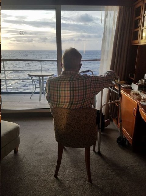
Above: Bishop. 24 September 2017.
Waiting to leave for dinner. Cabin 1104. Forward. Regent Seven Seas Mariner.
150 miles off central Florida east coast, proceeding north at 18 knots.
Swells don't look it, but they're 12 feet.
Ship is bouncing along as it positions to overtake Hurricane Maria, 200 miles to the east, in a feint to the west, early tomorrow morning.
Yucky seas, spawned by Hurricane Maria, expected all the way to NYC where arrival is scheduled for 7:00 AM, 27 September 2017.
Monday AM. 25 September 2017.
Regent Seven Seas Mariner is racing into the squeeze between North Carolina's outer banks and the outer rim of Hurricane Maria.
Cap'n's strategy to out run the storm on its west side seems to be working OK. BUT....seas are very heavy, with 18 foot swells and 60 knot apparent winds. Life on board ship is not very comfortable, with the prospect of respite soon, negligible.
Reclining...snoozing...reading...TV...is the best strategy.
Storm is weakening and is not expected to be a risk for the US northeast.

Above: TIMDT and Bishop. TIMDT's 39th. Regent Seven Seas Mariner. 25 September 2017.
Ship is northeast of NC Outer Banks, having outraced Maria, heading to the same spot. Cap'n has announced an early arrival in NYC, 26 September 2017, at 4:00 PM (as opposed to next morning, 27th, at 7:00 AM.

Above: TIMDT and birthday cake. Signature Restaurant. Birthday dinner. Regent Seven Seas Voyager. 25 September 2017.
Cake hat tip: SpaGo.

Above: SpaGo, Gayatri (butler), TIMDT. Regent Seven Seas Voyager. Birthday dinner. 25 September 2017.

Above: Spago, TIMDT, Montage. Our cabin. Regent Seven Seas Voyager.
Ship's crews' decorations for TIMDT birthday.
Addendum:

Above: Snow. Deer Valley. 25 September 2017.
Skipping autumn?


Above: Peterbuilt images at Alta. 25 September 2017.
Hello Taylors: It snows one day and melts the next. Rinse and repeat.
We are furnishing some hauling equipment to erect a new lift at Alta. Image taken 9/24/17. I'm sure healing is better at lower latitudes with good cruise ship food.
Peterbilt,
Salt Lake City, UT

Poor picture due to sun direction..
Funky car left running outside a market; windows opaque with slobber;
Three massive newfies inside
Enjoy your trip
ASPCA, Larkspur, CA
I have some interesting ancestral history with the Panama Canal on my mother's side of the family. In December 1886 my great great grandfather Jose Dolores Rodriguez was the Ambassador to the USA from the newly formed "Greater Republic of Central America," which was a short lived political union of Honduras, Nicaragua, and El Salvador (June 1885 - November 1898*). J. D. Rodriguez whose family dates back to Nicaragua starting in the 1500s, was received by President Cleveland and Secretary of State Olney in December 1896. At that time the USA was planning to build an inter oceanic canal through Nicaragua. On January 15, 1897 J. D. Rodriguez strongly objected to the proposal on the grounds of various provisions unfair to Nicaragua. The USA dropped their plans and years later finished the canal that the French had started in Panama. Interesting enough there currently is a Chinese consortium that negotiated a deal with Ortega in 2014 to build a new canal through Nicaragua. Due to financial troubles by the leaders of the consortium, odds are that this canal will not be built. The Greater Republic of Central America was dissolved in November 1898 when General Thomas Regaled seized power in El Salvador.
Nathans, Massapequa, NY
Fascinatin' (sic)!